

The Thailand is one of Southeast Asia’s leading destinations for marine tourism, renowned for its spectacular coastlines, tropical islands, and rich marine biodiversity. Along the Andaman Sea, stretching from Koh Lipe in the south to Ranong in the north, lies an extensive chain of islands, coral reefs, limestone formations, and world-class marine national parks that attract divers and ocean enthusiasts from around the globe. Famous for its clear waters, vibrant reef systems, and internationally recognized protected areas, Thailand plays an important role in regional marine conservation and sustainable diving tourism. It is also one of the active locations where Ocean Quest Global and ORR conduct educational and conservation-related initiatives focused on coral reef protection, ecological awareness, and responsible marine stewardship.


Maya Bay, located on Phi Phi Leh Island in southern Thailand, is one of the most iconic coastal environments in the Andaman Sea, renowned for its towering limestone cliffs, turquoise waters, and fragile coral reef ecosystems. Years of uncontrolled tourism caused severe ecological degradation to its reefs and coastal habitats, leading to the temporary closure of the bay for environmental recovery. My work in Maya Bay focuses on promoting ecological rehabilitation through organic reef restoration approaches, marine ecosystem assessment, and conservation awareness. Through field observations, educational initiatives, and reef rehabilitation efforts, the project emphasizes the importance of restoring natural biological processes while encouraging sustainable marine tourism and long-term protection of this globally significant marine environment.
MAYA BAY
Phi Phi Island
Phi Phi Islands & Hat Noppharat Thara–Mu Ko Phi Phi National Park — An Introduction
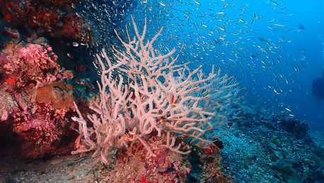
In the Andaman Sea, where tectonic history has carved stone into sculpture, the Phi Phi Islands rise as a dramatic contrast to the quieter reef systems of the region. Here, vertical limestone cliffs erupt from the ocean, their faces weathered by time, enclosing lagoons of impossible color and depth. It is a landscape defined not by subtlety, but by form. Sheer walls, hidden bays, and water that shifts from deep cobalt to luminous emerald within a few meters.
The archipelago consists of six islands, with Phi Phi Don and Phi Phi Leh as its most prominent. Phi Phi Don carries the human presence. Villages, longtail boats, and the rhythm of tourism, while Phi Phi Leh remains largely untouched, its cliffs enclosing places like Maya Bay, where the sea folds inward into a near-perfect amphitheater. These formations are the result of ancient coral reefs uplifted and sculpted over millions of years, leaving behind the karst towers that define the islands today.

All of this lies within Hat Noppharat Thara–Mu Ko Phi Phi National Park, a protected area that spans both coastal mainland and offshore islands. The park is not only a visual spectacle but a complex ecological system where limestone geology, tropical forest, and marine habitats intersect. Beneath the surface, coral reefs trace the base of the cliffs, adapting to steep drop-offs, variable light, and shifting sediment patterns. Unlike broad, shallow reef platforms, these systems are more fragmented, resilient in some ways, vulnerable in others.
What makes Phi Phi compelling is this tension between intensity and fragility. The same geological forces that created its iconic beauty also limit the space in which ecosystems can stabilize. Steep walls mean less room for expansive reef development, and enclosed bays are more sensitive to disturbance. Within the framework of the national park, management becomes not just about preservation, but about restraint. Understanding the limits of what these systems can absorb.
Phi Phi is often seen through the lens of its beauty, but its deeper story lies in structure and balance. It is a place where land and sea collide in their most expressive forms, and where the challenge is not discovering its value, but maintaining it.
MY MISSION
My mission at Phi Phi is purely education and it started in 2017, a year before the closure of Maya Bay. The period between April 2013 to April 2018 I am responsible for the development of Sea Shepherd Dive - Coral Propagation Training. The campaign with Sea Shepherd Dive ended in 2018 prior to the Maya Bay rehabilitation Initiative.
The training in Phi Phi resulted in development of one training nursery at Tonsai Pier. This initiative is supported by many dive centers on Phi Phi Island including Princess Divers, Barrakuda Divers, Blue View Divers, and Pura Vida. The staff from Marine National Park Operation Center 3 also begin their training at Phi Phi Island before moving all their training to Maya Bay and Trang.

Islands of Hat Noppharat Thara–Mu Ko Phi Phi National Park
The Phi Phi island group within Hat Noppharat Thara–Mu Ko Phi Phi National Park consists of six main islands. Together, they form one of the most iconic marine landscapes in the Andaman Sea, combining limestone geology, coral reef systems, shallow lagoons, and steep underwater walls.
1. Ko Phi Phi Don
The largest and only permanently inhabited island in the archipelago. Phi Phi Don is the social and logistical center of the islands, known for:
-
Ton Sai Bay and Loh Dalum Bay
-
The Phi Phi Viewpoints overlooking the twin bays
-
Snorkeling reefs and shallow coral gardens
-
Longtail boat culture and dive tourism
-
Vibrant nightlife alongside traditional fishing communities
Its narrow sand isthmus connecting two limestone masses gives the island its distinctive shape.
2. Ko Phi Phi Leh
A protected uninhabited island famous for dramatic vertical limestone cliffs and enclosed lagoons. Attractions include:
-
Maya Bay
-
Pileh Lagoon
-
Loh Samah Bay
-
Viking Cave
-
Deep-water cliff walls and reef drop-offs
Phi Phi Leh became globally recognized after the film The Beach, but it is also a case study in marine recovery and overtourism management.
3. Ko Mai Phai (Bamboo Island)
A low-lying island surrounded by shallow reefs and white sand beaches. It is known for:
-
Clear turquoise lagoons
-
Extensive snorkeling areas
-
Reef fish abundance
-
Gentle sandy seabeds ideal for beginner swimmers
Unlike the steep karst formations of Phi Phi Leh, Bamboo Island represents a flatter coral-sand island ecosystem.
4. Ko Yung (Mosquito Island)
Located north of Phi Phi Don, this island is less visited and more ecologically sensitive. Attractions include:
-
Hard coral reef systems
-
Clear-water snorkeling
-
Quiet reef slopes with fewer boats
-
Stronger currents suitable for experienced divers
The island’s reefs are important fish nursery habitats.
5. Ko Bida Nok
One of the premier dive sites in southern Thailand. This limestone islet is famous for:
-
Vertical underwater walls
-
Leopard shark sightings
-
Blacktip reef sharks
-
Caverns and swim-throughs
-
Soft coral growth on deeper slopes
The currents around Bida Nok attract pelagic species and create high-energy reef conditions.
6. Ko Bida Nai
Located beside Bida Nok, this smaller limestone outcrop is another renowned dive destination featuring:
-
Coral-covered walls
-
Macro marine life
-
Seahorses and nudibranchs
-
Reef crevices and overhangs
-
Calm conditions during certain tidal windows
Together, the Bida islands form an important underwater extension of the Phi Phi reef system.
What makes the Phi Phi National Park unique is the diversity compressed into a relatively small area. Within a single marine park, there are inhabited islands, enclosed lagoons, offshore reef pinnacles, shallow coral flats, cliff ecosystems, and deep-water walls. All interacting within the same Andaman Sea current system.


Koh Haa
Koh Haa is a small, dramatic archipelago in the Andaman Sea, part of Thailand’s Mu Ko Lanta National Park. The name “Koh Haa” literally means “Five Islands,” referring to a cluster of steep limestone islets rising almost vertically from the sea, their cliffs streaked with mineral stains and fringed by narrow white sand pockets. Located west of Koh Lanta in Krabi Province, these islands sit on the outer edge of the continental shelf, where clear oceanic water allows exceptional visibility and supports vibrant coral reef systems. Beneath the surface, the topography is just as striking. Submerged caverns, swim-throughs, and sloping reefs form a complex underwater landscape that attracts both marine life and divers from around the world.
The geography of Koh Haa is defined by its central lagoon, a semi-enclosed basin sheltered by the surrounding islands. This lagoon acts as a natural nursery, where calm, shallow waters provide refuge for juvenile fish and invertebrates, while the outer reef slopes descend into deeper blue water exposed to seasonal currents. These currents bring nutrients that sustain a diverse reef community, including hard and soft corals, reef fish, and occasional pelagic visitors. The combination of protection and exposure creates a dynamic ecological gradient within a very compact area. One of the reasons Koh Haa is considered both ecologically rich and visually spectacular.

MY MISSION
The conservation initiatives at Koh Haa begins in April 2016. My first mission at this location is to teach coral propagation to the diving community. This initiative materialize from the combined effort of the National Park and Pimalai Resort and Spa in Koh Lanta. The coral reef at Koh Haa presents a unique opportunity for long term observation. The coral reef at Koh Haa is dynamic and in a constant state of transition. Although many pioneer species has die out from recent bleaching, the transitory species are establishing well. From this, I am able to plot a decade of observation of the recent evolution of the reef here.
Koh Haa lies within Mu Ko Lanta National Park, a protected marine area established to conserve the region’s terrestrial and marine biodiversity. The park encompasses a chain of islands, coastal forests, mangroves, and coral reefs, forming an integrated ecosystem that supports a wide range of species. Management within the park aims to balance conservation with sustainable tourism, regulating activities such as diving, snorkeling, and anchoring to minimize impact on fragile reef habitats. As part of this protected network, Koh Haa benefits from relatively low fishing pressure and controlled visitor access, which has helped maintain its reef health compared to more heavily trafficked areas in the Andaman Sea.
Within this setting, my initiative at Koh Haa is grounded in a mutual collaboration with Khun Anurat and Pimalai Resort and Spa. This partnership brings together local stewardship, private sector support, and long-term ecological vision, aligning conservation efforts with responsible tourism. By working collectively within the framework of Mu Ko Lanta National Park, the initiative aims to strengthen reef resilience while fostering awareness and engagement among divers and visitors who experience Koh Haa’s unique marine environment.
Together, Koh Haa and Mu Ko Lanta National Park represent a compelling example of how geology, oceanography, and conservation intersect. The towering limestone formations are not only scenic landmarks but also the structural foundation for complex marine habitats, while collaborative efforts on the ground ensure that these ecosystems remain viable for future generations.

Koh Rok
Koh Rok & Mu Ko Lanta National Park — An Introduction
Out in the Andaman Sea, where the continental shelf dissolves into a mosaic of reefs and islands, Koh Rok rises with quiet authority. It is not dramatic in the way of towering limestone karsts or crowded bays. Instead, it reveals itself through clarity. Water so transparent that the reef beneath seems to breathe just below the surface, and shorelines where jungle meets sea without interruption.
Koh Rok is composed of two islands, Koh Rok Nok and Koh Rok Nai, separated by a narrow channel that funnels tidal flow between them. This movement of water is not incidental, it is the lifeblood of the reef system. The lagoon that wraps their shores is shallow, luminous, and ecologically alive, hosting coral communities that thrive in a balance of light, current, and protection. From above, the reef appears as shifting textures, patches, ridges, and sand corridors. Each one a habitat shaped over time.
MY MISSION
My mission at Koh Rok is part of the initiative to monitor and document the transition of the reef like those of Koh Haa. Although my work here begin a year later as compared to Koh Haa, it is still within the same period of reef development. Koh Rok presents a comparative background and in contrast to Koh Haa in its seafloor terrain and species distribution. As an observer, I did not carry out any interventions at this location. Data obtained from Koh Rok and Koh Haa is presented to the sponsors and the National Park.
These islands fall under the protection of Mu Ko Lanta National Park, a marine sanctuary that extends far beyond Koh Rok itself. The park is a network of islands, reefs, and open water systems that together form one of the Andaman Sea’s more intact ecological landscapes. Its significance lies not just in its beauty, but in its continuity. Forests above, reefs below, and the constant exchange between land and sea. The terrestrial side of the park is equally important. Dense tropical forest blankets the islands, stabilizing soil, regulating freshwater runoff, and feeding nutrients into coastal systems. What happens in the canopy is carried, slowly and invisibly, into the reef. This connection is often overlooked, but here it is intact, one system, not two.
Koh Rok, then, is not just a destination. It is a functioning example of how a reef should exist when given space, protection, and time. The clarity of its waters is not merely aesthetic. It is a sign of balance. And within the broader context of Mu Ko Lanta National Park, it stands as a reminder that marine ecosystems are not isolated fragments, but parts of a larger, living structure that begins on land and extends into the open sea.
Koh Bulone
Far to the south of Thailand’s Andaman coast, near the maritime border where waters begin to open toward Malaysia, Koh Bulone exists in a quieter register of the sea. It is not shaped by towering cliffs or dramatic geology, but by gentler forces. Sand, reef, and time. Here, the island feels less like a spectacle and more like a living shoreline, where the rhythm of the ocean is still allowed to define the landscape.
Koh Bulone is part of the Tarutao National Marine Park system, yet it remains one of its least disturbed expressions. The island is low-lying, edged with soft white beaches that dissolve gradually into shallow turquoise lagoons. Beneath the surface, coral communities spread across sandy seabeds in patches and gardens, adapted to calm conditions and filtered light. These are not steep drop-offs or high-energy reef walls, but quiet, productive systems—nurseries where life grows steadily rather than dramatically.
What distinguishes Koh Bulone is this sense of balance. The waters are clear, but not sterile; the reefs are active, but not crowded. Traditional fishing communities still operate here, their presence woven into the environment rather than imposed upon it. Boats rest lightly on the water, moving with tides that remain largely unaltered by heavy infrastructure. The island’s position also matters. Sheltered from some of the heavier tourism flows that shape more northern Andaman destinations, Koh Bulone sits within a corridor of relatively healthy marine systems. Seagrass beds, sandy flats, and coral patches connect in a continuum, supporting fish populations and maintaining ecological function beyond what is immediately visible.
Koh Bulone is not a place that announces itself loudly. Its value reveals itself through stillness, through the clarity of its shallows, the intactness of its reef flats, and the continuity between human presence and natural system. In a region where many islands have become defined by their intensity, Koh Bulone offers something increasingly rare: a reef and island system that still feels whole.
MY MISSION
Koh Bulone presents a challenge to conservation. Unlike the National Parks, Koh Bulone is open to fishing and have an active fishing community. Although this community is considered artisanal the fishing methods are semi industrial. This factor increase pressure on the reef ecosystem. Combined with the bleaching event of 2010 the reef are in desperate need for intervention. Here, my mission covers education and intervention. Coral curriculum are brought into the schools to educate children of the fisherfolks. Several coral nurseries are built to help speed up coral recovery. Most importantly the mission to retrieve numerous ghost nets on nearby reefs.

Koh Lipe
At the southern edge of Thailand, where the Andaman Sea stretches toward Malaysia, Koh Lipe sits like a threshold between worlds. It is part of the Tarutao National Marine Park, yet unlike many protected islands, it carries both the presence of a community and the weight of rapid transformation. Still, beneath that surface, the island’s original character remains unmistakable, clear water, shallow reefs, and a geography shaped by sand and sea rather than stone.
MY MISSION
My mission in Koh Lipe is to prepare a training nursery at Koh Kra adjacent to Sunrise Beach. Koh Lipe is an extension of the initiative first started at Koh Adang. Both are aimed at creating a platform for training and conservation.
Koh Lipe is a low-lying island, fringed by soft white beaches that arc gently into lagoons of striking clarity. The waters here are immediately revealing. Coral patches, seagrass beds, and sandy channels lie visible just beneath the surface, forming a mosaic of habitats that support a wide range of marine life. Unlike the steep limestone systems of the northern Andaman, Lipe’s reefs are more accessible, more open, and in many ways more vulnerable. The island is home to the Urak Lawoi’, a seafaring people whose connection to these waters predates modern borders and tourism. Their presence anchors Koh Lipe to a deeper history. One defined by movement, fishing, and an intimate understanding of the sea. Today, that relationship exists alongside a fast-growing tourism economy, creating a delicate balance between livelihood and preservation.
What defines Koh Lipe is this tension. It is both pristine and pressured, vibrant and fragile. The same shallow clarity that makes its reefs so inviting also makes them susceptible to anchors, to sediment, to the cumulative weight of human activity. Within the broader framework of Tarutao National Marine Park, Koh Lipe stands as both an opportunity and a warning: a place where the future of reef tourism is being negotiated in real time. Yet even with these pressures, the island still holds moments of quiet integrity. At sunrise, when the tide is low and the boats rest lightly over sand and coral, Koh Lipe returns to its natural rhythm. In those moments, it becomes clear that beyond its popularity, it remains what it has always been, a small island shaped by the sea, and dependent on its balance.

Butang Archipelago
Scattered across the southern reaches of Thailand’s Andaman Sea, the Butang Archipelago forms the living heart of Tarutao National Marine Park, a constellation of islands where reef, forest, and open ocean converge into one continuous system. Unlike singular destinations defined by one iconic feature, Butang is a network, and its strength lies in that connectivity. Each island, each reef, each current plays a role in sustaining the whole.
At its center lies Koh Lipe, the most developed of the group, surrounded by quieter, more imposing landmasses such as Koh Adang and Koh Rawi. Adang rises steeply, its dense rainforest feeding freshwater into the sea and anchoring the ecological balance of the archipelago. Rawi, by contrast, stretches low and open, its long beaches meeting shallow reef flats that extend far into clear water. Between and beyond them are smaller islands, rock outcrops, submerged reefs, and sandy cays that act as stepping stones for marine life moving through the system.
MY MISSION
My mission at Butang Archipelago spans over 2 years (2017 and 2018). It is mainly providing assistance to the Marine National Park Operation Center (MNPOC) on biodiversity survey. Although this group of islands are visited by tourists during daytime, there is not development allowed on the islands. Visitors can only come on daytrip to visit Butang Island. The last survey here is in April 2018. It is a prelude to the closure of Maya Bay on 28 May 2018. It is a stark contrast between idyllic Butang Island and the bustling town of Phi Phi where I first settled before the official closure of Maya Bay. The research team from MNPOC has supported my work here in the South Andaman sector of Thailand.
Beneath the surface, the Butang Archipelago reveals its true complexity. Coral reefs here are not uniform; they shift with depth, exposure, and current. Sheltered lagoons support coral gardens and juvenile fish populations, while outer reef slopes face stronger currents, drawing in larger species and creating dynamic feeding grounds. Seagrass beds weave through sandy channels, linking habitats and sustaining life cycles that depend on movement rather than isolation.
What makes Butang significant is not just its biodiversity, but its relative continuity. Compared to more heavily impacted regions, many of its systems still function with a degree of natural rhythm. Tides move freely, sediment flows remain largely undisturbed, and ecological relationships persist across land and sea. Yet this balance is not guaranteed. With Koh Lipe acting as a gateway, pressure is steadily increasing, making the management of the archipelago not just a matter of protection, but of restraint and foresight.
The Butang Archipelago is, in essence, a living framework. It is where island, reef, and ocean are inseparable. Where the health of one is reflected in the others. To understand it is to see beyond individual beaches or dive sites, and to recognize a system still holding together, but increasingly aware of its own limits.
Similan and Surin
Rising from the Andaman Sea like scattered jewels, the Similan Islands are among the most celebrated marine landscapes in Southeast Asia. Part of the protected Mu Ko Similan National Park, this remote archipelago is defined by its striking contrasts, giant granite boulders sculpted by time, powder-white beaches that seem untouched, and waters so clear they dissolve the boundary between surface and depth.
Beneath that calm surface lies a world of remarkable ecological richness. The Similans sit within the eastern reaches of the Andaman Sea, where nutrient flows and oceanic currents sustain vibrant coral communities and an abundance of marine life. For divers, it is a place of both spectacle and subtlety: reef mantas gliding through blue water columns, intricate hard coral gardens thriving in sunlight, and hidden macro life tucked into the reef’s quiet corners.
MY MISSION
My mission in Similan Island is driven by the need to assess and document the damage on the reefs. Similan is highly protected chain of islands in the North Andaman sector of Thailand. The 2004 tsunami devastate almost the entire ecosystem. More than a decade later in 2017 the same ecosystem forego several more catastrophic impact of bleaching and severe storms. However, the continental plate of the Andaman ridge play important role in the rebound and recovery of corals in Similan and Surin. It is my opportunity as an observer to document the resilience of the marine life and the recovering reefs.
Yet beyond its visual beauty, the Similan Islands embody a deeper narrative. One of resilience and protection. Strictly managed seasons and conservation measures have preserved much of what makes this ecosystem exceptional, offering a rare glimpse of what tropical reefs can be when given space to breathe. In this balance between exposure and protection, the Similans stand not just as a destination, but as a living testament to the value of safeguarding the natural world.